CYCLONE HOLA AN IMPRESSIVE SYSTEM – ON TRACK FOR MONDAY. ( NORTH ISLAND EVENT )
Updated 4:00pm Sunday evening
CYCLONE HOLA – A REAL THREAT TO PARTS OF THE NORTH ISLAND ( HEAVY RAIN, STRONG WINDS & POSSIBLE COASTAL DAMAGE POSSIBLE)
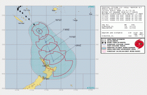
Tropical Cyclone Hola is now a category 2 tropical cyclone and is fast approaching the upper North Island. It’s currently weakening and will continue to weaken as it moves south into our cooler waters. While losing it’s impressive titles, this system remains a real threat to parts of the North Island and we have high confidence of a period of heavy rain, gales and possible coastal damage.
Maps, models and data are now in alignment and we now have high confidence that exposed parts of the North Island will see severe weather for a time on Monday & during the early hours of Tuesday morning near Gisborne.
At this stage and it’s remained consistent for over 10 days the upper North Island looks most exposed. Northland, Auckland, Waikato and possible even parts of the Bay of Plenty. Heavy rain, strong winds and impressive swells are possible and associated coastal damage.
QUICK FIRE SUMMARY POINTS
1. Cyclone Hola won’t have any effect here in Canterbury. Next week is looking sunny, settled and mild on current analysis. At a push we may see impressive swells north of Kaikoura,but this remains low risk (10%) on the current path forecast of Hola.
2. The upper North Island and East Coast of the North Island will experience the more severe weather This has remained consistent for some time. 70-80% chance. Auckland is likely to experience strong winds and heavy rain for a time on Monday & perhaps in the early hours of Tuesday morning.
4. Threats for the North Island include strong winds around 120km/hr gusts and persistent winds around 60-70km/hr. Rain will be high intensity, with rates possible around the 15-25mm/hr. Grand totals could exceed 110mm, keep in mind this is a fast mover. Possible flooding & wind related damage. Coastal damage to the East Coast of the North Island and upper North Island is considered a moderate chance. This will be a fast moving active system of weather (6-10 hours ) and by Midday Tuesday the whole North Island will be in the clear.
Those living and operating in the North Island keep up to date with MetService for all the latest ‘Watches’ & ‘Warnings’.
Maps/graphics: Current tracking of Cyclone Hola Sunday evening. Knocking on the door in the upper north. Click on the image for more clarity. Source: JTWC (Joint Typhoon Warning Center)
Weather Analyst: Russell Voice
Copyright NZ REGIONAL WEATHER UPDATES 2018


