3 SYSTEMS/PERIODS OF WEATHER TO WATCH
•We’ve seen tweaks and refinements – keep up to date with our warnings and watches for all the latest -3:10pm Wednesday afternoon.
THREE SYSTEMS/PERIODS OF WEATHER TO WATCH
•A deep low moves south tomorrow, bringing severe weather to parts of the North Island on Thursday and Friday. By late Thursday we start to see a gradual deterioration in our weather here in Canterbury, with widespread rain and occasionally heavy falls on Friday. We may also see elements of ‘Warm Advection’ snow in the Mackenzie Country – west of Burkes Pass, early Friday and we currently have a heavy snow watch in place covering the potential for lower and heavier snow. For most of Canterbury, snow levels will remain at high elevations on Friday, remember this ‘pool’ of air and moisture has sub tropical origins. A messy and complex day – further refinements are likely on town pages over the next 48 hours.
•Southerlies arrive on Saturday, with very cold air then spreading north, lowering snow levels, especially by evening, with falls about the foothills. Snow may fall to 300m in parts of Canterbury, with more sustained falls around the 500-600m elevation. There is the potential for some heavy snow about our alpine villages and higher roads and passes and a range of Canterbury Weather Updates warnings and watches may follow over the next two days. Snow may cause a range of disruptions and closures during the weekend about our higher alpine passes. Farmers living and ‘operating’ about the hills should prepare for a period of snow, especially those above 600m. Snow showers will linger in parts of the region on Sunday, especially about the Hurunui and Kaikoura Districts, capping off a very cold, wet and snowy weekend for many.
•Early next week, another ex-tropical low may bring more widespread easterly rain and even snow about the hills capping off a very unsettled 7 day period. This remains a fluid situation and we hope to have more model consistency by Friday.
Keep up to date with our town pages, warnings/watches and live weather feed, for all the latest information.
MSLP MAPS
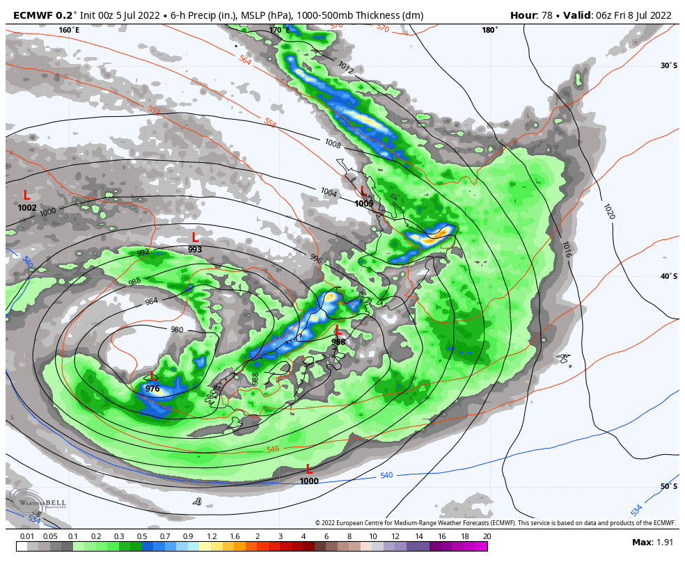
Map above – Friday. Capturing our large area of low pressure, with rain affecting the entire country at various stages and levels of intensity. Model – ECMWF

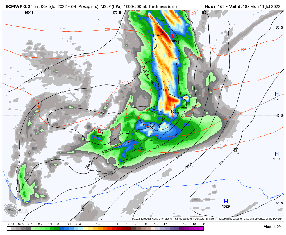
Map above – Saturday. Illustrating our colder southerly airflow, that may bring widespread rain and snow to the foothills. Model – ECMWF.
Map above – Monday next week, with another system possible from the tropics. This may bring even more significant rain to parts of New Zealand, with eastern and northern parts of New Zealand most exposed. Model – ECMWF.
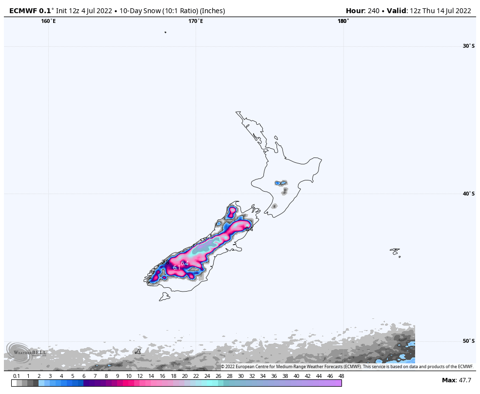
Map above – snowfall accumulation guide until Thursday next week. Fantastic snowfall is likely for most, if not all our ski fields, with 100cm+ forecast for some fields. Model – ECMWF.
(C) NZ Regional Weather Updates