SUPERB LOOKING LONG WEEKEND – AUTUMN AT IT’S FINEST.
Updated 5:40pm – Wednesday evening 28/03/2018.
EASTER WEEKEND – WHAT’S IN STORE HERE IN CANTERBURY??
The questions are flooding in, how’s Easter looking? Well it’s looking superb for Canterbury under high pressure. We have one slight blemish, a cooler weak southerly front that will work north on Saturday afternoon, but it doesn’t have a lot of sting and will lose its momentum on arrival here in Canterbury; perhaps a few isolated showers and a cooler ‘pool’ of air for a 6-8-hour period. Rainfall – isolated in nature, with 1-5mm for most of Canterbury.
Overall, it’s looking superb across the region, with mostly sunny skies, settled conditions and yes, it will be around 3-4 degrees above average for the time of year. Perfect for heading into the High Country and getting out and making the most of the long weekend. In terms of winds, we’re looking at gusty NW conditions on Saturday afternoon & evening for the High Country and just those frequent easterlies about Coastal Canterbury, we don’t expect any real ‘Punch’ with winds expected to remain below 30km/hr.
FRIDAY: Sunny skies with settled conditions across the region. Areas of morning low cloud and fog possible. Light NE winds, freshening a tad about Coastal Canterbury, remaining light inland. Mild temperatures, a few degrees warmer inland away from those onshore winds. Conditions changing late at night about the Main Divide, with strong NW winds developing. CWU PICK: Hanmer Springs and inland areas & basins. H: 21-24 L: 7-10
SATURDAY: Mostly sunny, with high cloud developing during the afternoon & evening. Mild conditions. NE winds freshening about Coastal Canterbury, with NW winds gusty in the High Country; strong to gale force at higher elevations. Afternoon southerly change, with rain near the Main Divide and a few showers spreading north about the Canterbury Plains & Coast. Any shower activity clearing at night. CWU PICK: Akaroa & North Canterbury especially about the Coast. H: 22-25 L: 9-11
SUNDAY: A cooler start, especially about the higher elevations. Sunny and settled weather across the region.We may see low cloud and fog about low lying areas during the morning, but any fog or cloud will quickly burn off. Light winds for most, NE winds freshening about the Coastal Canterbury. Mild temperatures. CWU PICK: The Mackenzie Country and inland basins/areas. H: 21-23 L: 5-7
MONDAY: Superb weather under high pressure. Sunny skies, with light winds across the region; we may see NE winds freshen a little about Coastal Canterbury, but overall very settled conditions. Mild conditions, slightly warmer inland. CWU PICK: Through the interior & High Country. H: 22-25 L: 7-9
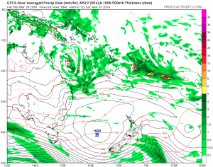
Map: A computer generated map for Saturday. In terms of a key talking points, this will be as bad as it gets during the weekend; a brief southerly change on Saturday afternoon. Notice the green ( moisture ) out to the east of the South Island, that’s our weak southerly change and the large high pressure in the Tasman set to move in and dominate our Sunday & Monday. Traditional Canterbury weather patterns and overall pretty settled across New Zealand. Source: GFS -https://www.tropicaltidbits.com/
Remember we’re still a few days out and may see a few little changes over the next few days. CWU provide the only moderated content for the past 5 days = unmatched detail & accuracy for the Canterbury region ( 23 towns across Canterbury – 7 day forecasts ).
Weather Analyst: Russell Voice


Derek 25th March
Great heads up for Easter
Thanks so much
Marg 25th March
Brilliant thanks
Lucy 28th March
We are intending to,stay here in wonderful Christchurch this weekend, but COULD well be tempted with a trip to Hanmer of course …. 😂😍🤪