CYCLONE UESI ON TRACK FOR THE WEST COAST OF THE SOUTH ISLAND
Updated Thursday morning 10:30am 13/02/2020.
The latest analysis continues to show the West Coast of the South Island will face another significant rain event, with more flooding and slip concerns from the remnants of TC Uesi.
Uesi is still a Severe Category 3 storm and is moving into the north Tasman Sea currently, but will gradually weaken slightly as it’s tracks south into our cooler waters and will be classified as an extra tropical-cyclone and deepening low, despite losing it’s title this system demands respect, especially those in the current firing line about the West Coast of the South Island – south of around Greymouth.
We’re current looking at landfall & influence from late Saturday night and during the early hours of Sunday morning, before the higher intensity falls ease back late Sunday night, through early stages of Monday morning.
Fiordland & parts of Westland look most exposed to the heavier & more persistent falls, with some computer guidance suggesting over 180mm, with rainfall rates possibly exceeding 25mm/hr.
Here in Canterbury some scattered showers may affect parts of the Canterbury Plains & Coast on Sunday, but our main concern is for those about the West Coast of the South Island, especially the lower half, which have already received significant rainfall and is still recovering from earlier in the month.
Those thinking of travel and taking part in recreational activities in Fiordland and about the Canterbury Headwaters and Otago Headwaters should be making back up plans and keeping up to date with the latest weather forecasts. A range of warnings are likely to be issued on Friday.
•All towns have now been adjusted accordingly with specific details. In terms of towns covered at CWU, Arthur’s Pass Village will receive significant rainfall and possibly Mt Cook Village. More details and refinements over the coming days.
KEY POINTS
•Currently this is a West Coast event; with an emphasis on the lower half, more into Fiordland, than say areas north of Greymouth; although the exact ‘path’ will remain fluid and will change around over the next few days.
•Heavy rain about the Canterbury Headwaters will have our main river systems running higher than usual from late Sunday afternoon, through early stages of next week. Rivers may be in flood, depending on rainfall totals and intensity on Sunday.
•We may see strong nor-west or northerly winds across the South Island on Sunday; stronger northerly or nor-easterly winds may affect the Canterbury Plains & Coast.
•Impressive swell systems off the West Coast of the South Island. Take care around beaches and rivers.
•Many dry parts of New Zealand look set to dodge the ‘bullet’ and escape any real precipitation of significance.
•Sea temperatures remain above average in the Tasman, helping maintain system intensity.
•The tropics are ‘heating’ up, we have another system of interest, which may pass off to the east of New Zealand next week and another system later in the month which may bring rain to eastern parts of New Zealand.
•Keep up to date with our town pages and ‘Live Weather Feed’ for all the latest information.
News Article Image at the top.
Recent satellite image shows Uesi spinning west of New Caledonia.
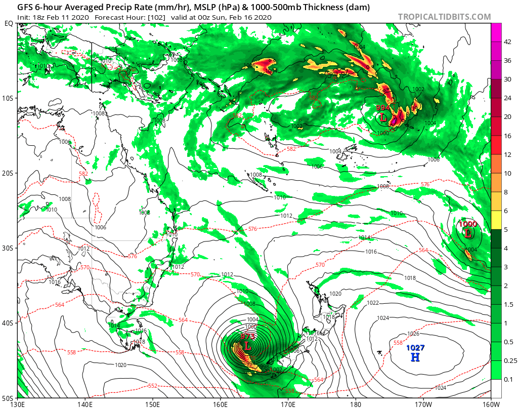
•Map above – Sunday morning, rainfall rate and pressure MSLP. Model source GFS.

•Map above – an impressive moisture ‘river feed’, which paints the ‘path’ of our cyclone as it tracks south in the Tasman Sea and onto the bottom half of the West Coast of the South Island. Model source GFS.
(C) NZ Regional Weather Updates.